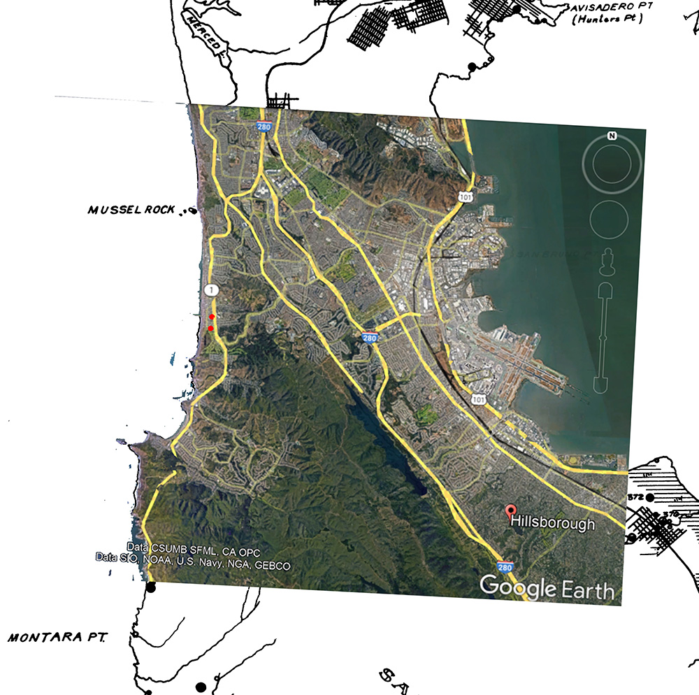
The network map below shows the relationships between the Quarry applicant Baylands Soil Pacifica LLC and the 2021 bribery-convicted felons Varela and Gilmartin

The network map below shows the relationships between the Quarry applicant Baylands Soil Pacifica LLC and the 2021 bribery-convicted felons Varela and Gilmartin

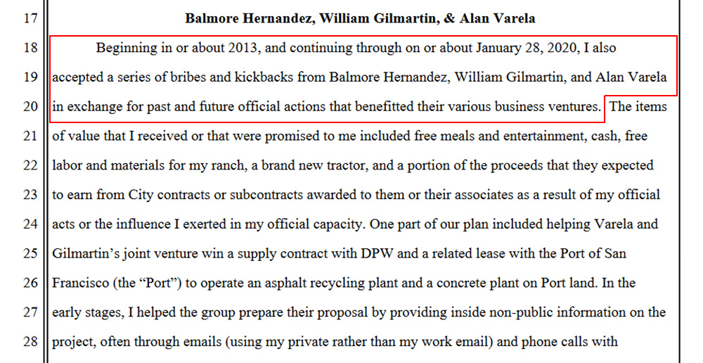
US District Court Case 3:21-cr-00490-SI US Attorney Stephanie Hinds published Dec 17 2021 pleas from SF Public Works Director Mohammed Nuru detailing how he’d been bribed by William Gilmartin & Alan Varela. Varela was sentenced to two years and Gilmartin’s sentencing is still pending.
https://www.smcfree.com/us/gov.uscourts.cand.361954.1.0.pdf
US District Court for Northern California Case 3:20-cv-04442-SK “Marr vs Pipe & Plant Solutions Inc” lays out the claims involving Proven Management Inc, William J Gilmartin IV, Alan Varela, William J Gilmartin III and Sewerai Corporation of Delaware. These three overlapping corporate entities receive hundreds of thousands of dollars of revenues from the City of Pacifica.
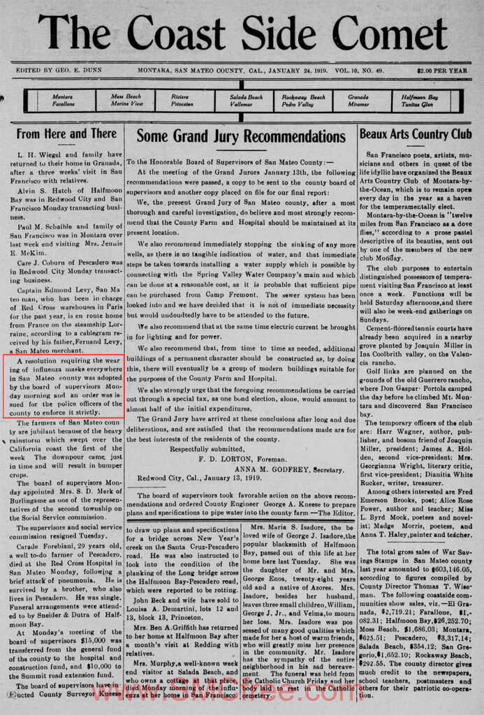
A resolution requiring the wearing of influenza masks everywhere in San Mateo county was adopted by the board of supervisors Monday morning and an order was issued for the police officers of the county to enforce it strictly.
Dunn, Geo. “From Here and There”. The Coast Side Comet, 24 Jan 1919 pp.1
There is extensive evidence that supports the Rockaway Quarry at Calera Creek may be the long lost Native American village of Timigtac, with archeologist Stephen A Dietz in 1974 writing in “Report of Archaeological Investigations”:
“The headman of the San Pedro valley village of Pruristace and one of his co-wive brought two of their children to be baptized in February of 1779. Along with them came two girls from “Timigtac”, commonly called la Calera”. Calera Valley is now the location of Rockaway Beach in the City of Pacifica (Map 2)”, and
“Of the 40 persons from Pruristac and Timigtac who had been baptised in the 1770’s and 1780’s, 25 were still alive at the end of 1793. In the late winter and early spring of 1795 a terrible epidemic struck the mission rancheria, taking over 200 lives in a few months.”
The National Park Service wrote in “Early Mori Point History and Its Quarry” Historic Resource Study for Golden Gate National Recreation Area in San Mateo County” that:
“The Aramai village of Timigtac, thought to have been in the Rockaway Beach area, may have existed at Mori Point… Whether these Indian people called the place Timigtac or not, an archeological survey in 1969 recorded a shell midden present, leaving no doubt that prehistoric people occupied the site”, and
“During the Spanish period, Mori Point was within the jurisdiction of the Franciscan padres at Mission San Francisco de Asis. After secularization, Francisco Sanchez obtained Mori Point as part of his Rancho San Pedro.”
“The limestone at Mori Point has been utilized by all the cultures associated with the site. Archeological evidence suggests the Indians of the villages of Pruristac and Timigtac quarried limestone for use in construction, decoration and trade. The resource was duly noted by the Spanish. Beginning in 1776, they used Indian labor to quarry the limestone at Mori Point for their projects at San Francisco. They employed limestone for construction of the Presidio and used a variety of stone, gravel and shell from Mori Point to build both the Presidio and the mission buildings“, and
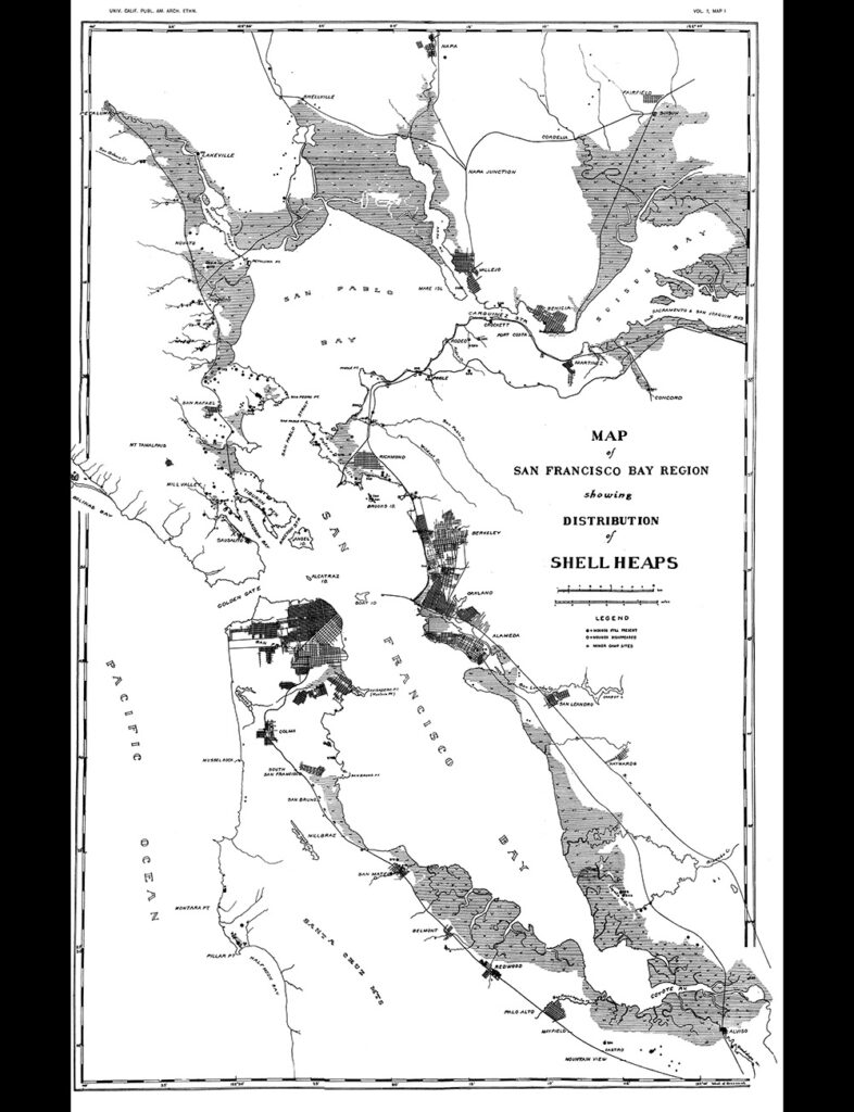
“Lime pits from the site were utilized to produce whitewash as a sort of paint for the structures. The Spanish also used Mori Point limestone to create the whitewash for the San Pedro y San Pablo outpost in the San Pedro Valley.”The California Journal of Mines and Geology, Vol 43, No 3, July 1947 states:”The deposit is of Franciscan (Jurassic ?) Limestone and Chert, forming Calera Hill which rises 300 feet above sea-level…apparently some lime was made her many years ago, as Eckel mentioned remains of some old kilns seen there.” 7 Buttressing Deitz and the National Park Service is the NC Nelson Map of San Francisco Bay Region showing Distribution of Shell Heaps 1909 shows two visible shell mounds above Rockaway Beach when the author walked these parcels in 1909.
A satellite map overlay of the Nelson shellmound map shows Shell Mounds above the quarry parcel in what appears to be the Clarendon corner of the Sharp Park Golf Course and another along Francisco Blvd. It is significant that the current shoreline closely matches the shoreline from 113 years ago.
While it is more likely that the Timigtac settlement and any related shellmounds are on the Rockaway Quarry parcel near the fresh waters of Calera Creek than farther north, if Timigtac were to be discovered elsewhere, it would pose additional challenges to other pending projects including those immediately north of the Sharp Park Golf Course , making it is especially important that a modern Tribal Resources Assessment be performed.
Archaeologists agree that
1. Timigtac was in Rockaway Beach along Calera Creek.
2. Native Americans were enslaved by the Spanish Missions to mine limestone on the Rockaway Quarry parcel for both San Francisco’s Presidio fort and Mission Dolores.
3. Native American shellmounds exist on the quarry parcel
Less than three days remain until public comments for Pacifica’s Rockaway Quarry reclamation plan are due (Monday April 4 at 5pm). Over the past two weeks we’ve filed hundreds of federal and state records requests for historical documents and believe it is statistically likely that the Rockaway Quarry was the long-lost Native American village of Timigtac.
Pacifica-based Native Americans who were not wiped out by syphilis in 1790 and measles in 1792 were essentially enslaved at Mission Dolores (aka Misión San Francisco de Asís) between 1776 and 1839 in SF (where the remains of 5,000 are interred). They were forced to both quarry limestone from the Rockaway Quarry and fresh water from San Pedro Valley Creek in Linda Mar to build both the San Francisco Presidio & Mission Dolores (aka Misión San Francisco de Asís).
One very important thing to include with your public comments should be that “the Holman and Associates Archaeological Consultants (2002) Historical and Cultural assets source on the DEIR is outdated, incomplete, and inadequate and a new ‘historical and cultural assets’ assessment needs to be performed and that the DEIR must be restarted from scratch.”